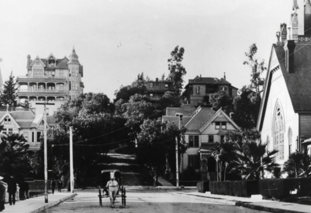
5. Publish-ready article What Happened to Old Bunker Hill, Los Angeles? Before Walt Disney Concert Hall, The Broad and the glass towers of Grand Avenue, Bunker Hill was one of Los Angeles’s most distinctive residential neighborhoods. Victorian mansions stood above downtown. Angels Flight carried residents between the hill and the commercial streets below. By the middle of the twentieth century, the mansions had largely become apartments, rooming houses and inexpensive hotels occupied by a diverse working-class community. Then Los Angeles erased almost all of it. The disappearance of old Bunker Hill was not a natural stage of neighborhood change. It was the result of an official urban-renewal program that acquired land, relocated thousands of residents, demolished nearly the entire built environment, redesigned the streets and extensively regraded the hill. What followed was not simply a cleaner version of the same neighborhood. It was a different district built for different people and purposes. In short: Los Angeles approved the Bunker Hill Urban Renewal Project in 1959. During the 1960s, the city’s redevelopment agency cleared the old neighborhood and displaced at least 8,000 people. Offices, apartments, hotels, parking facilities and major cultural buildings eventually rose on the site. What Was Old Bunker Hill? Bunker Hill rises immediately west of Los Angeles’s historic downtown core. Long before it was subdivided, the area formed part of the traditional homeland of the Tongva people. In the late nineteenth century, developers Prudent Beaudry and Stephen Mott helped transform the hill into an early residential suburb above the growing city. Its elevation was part of the appeal. Residents could escape the dust, congestion and noise below while enjoying broad views across the Los Angeles Basin. During the boom years around the turn of the twentieth century, wealthy Angelenos built elaborate Queen Anne and other Victorian-era houses along streets such as Olive, Hope, Grand, Clay and Bunker Hill Avenue. The Bradbury Mansion, completed in the 1880s near Hill and Court streets, had dozens of rooms and multiple turrets. Other residences later remembered as the Castle and the Salt Box became visual symbols of the neighborhood. These houses did more than shelter their owners. They advertised wealth, social standing and confidence in the future of Los Angeles. The neighborhood also became closely connected to downtown life. The Third Street Tunnel opened through the hill in 1901. That same year, Angels Flight began carrying passengers between Hill and Olive streets. Its two counterbalanced cars, Sinai and Olivet, turned a steep climb into a short daily ride. From Victorian Enclave to Working-Class Neighborhood Old Bunker Hill did not remain an exclusive enclave. As Los Angeles expanded west and affluent residents favored newer districts, many of the hill’s large houses were divided into apartments and rooms. Purpose-built apartment buildings and residential hotels also appeared. By the 1920s, 1930s and 1940s, Bunker Hill had become a dense and comparatively inexpensive place to live near downtown employment, shopping and public transportation. Its residents included older adults, low-wage workers, families, immigrants from Mexico and across Asia, Dust Bowl migrants and Native Americans drawn to Los Angeles under federal relocation policies. That history matters because the familiar phrase “the mansions declined” can erase the neighborhood that came next. Bunker Hill was no longer the home of the city’s wealthiest families, but it was not empty. Grand houses had become crowded apartments; aging buildings were also homes, businesses and social networks. USC’s Bunker Hill Refrain project uses 1939 housing-survey cards, census data, archival photographs and oral histories to recover this human geography. Its researchers emphasize that the neighborhood contained a diverse working-class population whose experiences were often reduced to official descriptions of physical decay. Why Did Los Angeles Call Bunker Hill “Blighted”? By the mid-twentieth century, Bunker Hill had genuine problems. Many buildings were old and poorly maintained. City surveys documented overcrowding, unsafe structures, fire risk and poor living conditions. In litigation over the redevelopment plan, the California Supreme Court cited a 1957 survey in which the Department of Building and Safety classified 239 of 395 buildings as dangerous. City officials also presented evidence of elevated crime, arrest and fire rates. Those facts should not be hidden. But neither should the political power of the word blight. Under state redevelopment law and the federal Housing Act of 1949, a blight designation gave public agencies a pathway to acquire property, clear land and use public financing to encourage private redevelopment. The label therefore described conditions and enabled a particular solution. Los Angeles could have pursued rehabilitation, selective preservation and new affordable housing alongside the existing community. Instead, the 1958 redevelopment plan explicitly stated that it contained no rehabilitation section. The entire project was treated as a redevelopment area. That is the crucial distinction. The city did not merely decide that Bunker Hill needed help. It decided that the old neighborhood itself would not be part of the future. How the Bunker Hill Redevelopment Project Worked Los Angeles created its Community Redevelopment Agency in 1948. The Bunker Hill project began in 1955, and the City Council adopted the official plan on March 31, 1959. Property owners and taxpayers challenged the plan in court. In 1964, the California Supreme Court upheld it, allowing the CRA to proceed with land acquisition, relocation, demolition, site preparation and bond financing. The redevelopment area covered roughly 136 acres in the heart of downtown. The project’s stated goals included modern housing, better circulation, parking, commercial development and public or cultural uses. Its economic logic was equally important: centrally located land occupied by low-rent housing could produce far greater tax revenue if assembled and redeveloped for higher-value uses. This was the classic mid-century urban-renewal model—a public agency cleared and prepared the land, then worked with private and public developers to construct a new district. Who Was Displaced From Bunker Hill? The human cost is difficult to reduce to one perfect number. Bunker Hill Refrain reports that official records show at least 8,000 people were displaced and cautions that the actual number was probably higher. Other historical scholarship commonly places the population at about 9,000. Many residents were poor, elderly or dependent on the neighborhood’s inexpensive rooms and apartments. Some were eligible for relocation assistance or public housing, but relocation did not recreate the community they lost. Affordable units, familiar stores, transit access, neighbors and informal support networks could not simply be packed into a moving van. New housing eventually appeared on Bunker Hill. Bunker Hill Towers began opening in the late 1960s, and other residential projects followed. But that fact does not mean the displaced community returned. Much of the new housing targeted a different and more affluent market, while the promised supply of comparable low-cost replacement housing on the hill failed to materialize. Urban renewal changed not only the buildings but also who the neighborhood was designed to serve. Did Los Angeles Really Flatten Bunker Hill? “Los Angeles flattened Bunker Hill” is a dramatic phrase, but it contains a physical truth. The entire geological hill did not disappear. The redevelopment process did, however, clear the old buildings, remove or realign streets and heavily regrade the terrain. Clay Street and Bunker Hill Avenue vanished. Other streets no longer follow the old grades. According to PBS SoCal’s account of the last house on the hill, earthmoving equipment removed roughly 30 feet from the summit. Photographs from the late 1960s show isolated structures perched on temporary columns of earth while surrounding parcels had already been cut down. By the summer of 1969, virtually all of old Bunker Hill’s Victorian landscape was gone. Two of its last well-known houses, the Castle and the Salt Box, were moved in 1969 to the future site of Heritage Square. Their rescue failed tragically: both were destroyed by fire later that year. The result was the blank slate redevelopment planners wanted—large, consolidated parcels suitable for towers, garages and a new street system. What Replaced Old Bunker Hill? The replacement did not arrive overnight. Some cleared parcels sat vacant for years, and the full transformation stretched across decades. Early projects included residential towers and The Music Center. The office-building boom accelerated later, especially during the 1970s and 1980s. Hotels, corporate plazas, parking structures and high-rise apartments reshaped the skyline. Over time, Bunker Hill also became Los Angeles’s leading cultural corridor. MOCA opened on Grand Avenue, Walt Disney Concert Hall followed in 2003 and The Broad opened in 2015. Along with The Music Center, the Colburn School and nearby institutions, these buildings made Grand Avenue an international arts destination. This produces the uncomfortable dual truth of modern Bunker Hill. The neighborhood contains important architecture, art, music, housing and public space. It also rests on the deliberate destruction of an earlier community whose residents did not share equally in the benefits. Calling today’s district “lifeless” is too simple. Calling the redevelopment an uncomplicated success is equally misleading. What Remains of Old Bunker Hill Today? Angels Flight is the most recognizable physical survivor, but even it is not exactly where it began. The railway operated beside the Third Street Tunnel from 1901 until it was dismantled in 1969. Its equipment then remained in storage for decades. In 1996, Angels Flight was reconstructed half a block from its original location, not on the exact original path. After later safety closures, it reopened in 2017. The Los Angeles Conservancy recognizes it as one of the city’s most enduring landmarks. Almost none of old Bunker Hill’s houses or intimate street pattern survives on the hill itself. The memory of the neighborhood instead lives in other forms: Los Angeles Public Library and USC archival photographs William Reagh’s documentation of the area’s final years Leo Politi’s paintings and drawings Oral histories from former residents and descendants The Bunker Hill Refrain digital reconstruction project Films shot on location before demolition This is why the claim that Los Angeles preserved “nothing” goes too far. The physical loss was extraordinary, but archivists, artists, filmmakers, preservationists and families have worked for decades to keep the neighborhood legible. Bunker Hill in Film Noir and Los Angeles Memory Old Bunker Hill became one of Hollywood’s most useful images of urban Los Angeles. Its steep stairways, Victorian facades, apartment hotels, tunnels and funicular appeared in films including Criss Cross, Cry Danger, M and Kiss Me Deadly. The most important record may be Kent Mackenzie’s The Exiles, filmed on location in 1958 with nonprofessional Native American actors. The movie follows young Indigenous residents through downtown bars, shops, apartments and streets. According to the American Film Institute catalog, locations included Angels Flight, the Third Street Tunnel, Grand Central Market and apartments on Clay Street. The film does something official redevelopment photographs often do not: it shows people inhabiting the neighborhood. Bunker Hill appears not simply as a collection of deteriorating structures, but as a lived environment filled with movement, loneliness, friendship, work and desire. The Real Lesson of Old Bunker Hill Bunker Hill was not demolished because every building was sound, nor was it cleared simply because every official was malicious. The truth is more revealing. Los Angeles faced an aging neighborhood with serious housing problems and chose a redevelopment system that valued land assembly, tax production, modern architecture and elite visions of downtown over continuity, rehabilitation and resident return. Public power made the transformation possible; private and institutional development captured much of the long-term value; thousands of low-income residents absorbed the disruption. The story therefore remains relevant whenever Los Angeles debates housing, homelessness, historic preservation and gentrification. A city can improve buildings while destroying a community. It can create celebrated architecture while erasing the social world that occupied the same ground. It can call the result progress and still owe the past an honest accounting. Old Bunker Hill did not vanish. It was removed by policy. Remembering that difference is the beginning of understanding what Los Angeles lost.

Bunker Hill – Victorian LA Gone

What happened to old Bunker Hill in Los Angeles? Los Angeles designated Bunker Hill for urban renewal in the 1950s. During the 1960s, the Community Redevelopment Agency acquired property, displaced at least 8,000 residents, demolished nearly the entire neighborhood, rebuilt streets and regraded parts of the hill. Offices, apartments, hotels and cultural institutions later replaced the Victorian and working-class district. What was Bunker Hill in Los Angeles before the skyscrapers? Bunker Hill began as a fashionable late-nineteenth-century residential district filled with Victorian homes. By the early and mid-twentieth century, many houses had become apartments and rooming houses occupied by a diverse working-class population. Why did Los Angeles demolish Bunker Hill? City officials classified the area as blighted and used state redevelopment law and federal urban-renewal funding to acquire property, relocate residents, demolish buildings and prepare the land for modern housing, offices, hotels, parking and public uses. How many people were150

Malibu – Paradise, Privacy, Fire, and the Road That Changed Everything

  Malibu’s history is built around one unresolved tension: people are drawn to its beauty because it feels secluded, yet every road, home, business, and celebrity arrival makes that seclusion harder to preserve. The story begins long before Hollywood, with the Chumash community of Humaliwo. It then moves through Spanish and Mexican land grants, American property law, and the creation of the vast Rindge ranch. After Frederick Hastings Rindge died, his widow, Rhoda May Knight Rindge, fought railroads, government surveyors, homesteaders, and the State of California to keep the estate private. Her defeat cleared the way for the coastal highway that opened Malibu to outsiders. Financial pressure also pushed her to lease beachfront lots to movie stars. Together, those developments transformed a private ranch into one of the world’s most recognizable coastal communities. But the same geography that made Malibu desirable also made it dangerous. Dry chaparral, steep canyons, seasonal150

Gardena Living

Acomprehensive look at the history, evolution, and cultural shifts of Gardena, California. The documentary explores how the city transformed from an agricultural hub into a unique suburban landscape shaped by World War II, social changes, and the rise of its famous card clubs.  Was Gardena Originally Agricultural Land? Originally a farming community founded by Abram Pomeroy in 1887, Gardena was known for its truck farms and dairy production before officially incorporating in 1930. The Impact of World War II The film details the forced relocation of the city’s significant Japanese American population to internment camps, a devastating event for the community. It also highlights the service of the 442nd Regimental Combat Team, a highly decorated unit composed of Japanese American soldiers. Social Shifts and Integration The documentary examines the changing demographics of the city, particularly following the Watts Riots in 1965, and the gradual process of racial integration, including the150

Best 12 Los Angeles Neighborhoods LA

Twelve best Los Angeles neighborhoods: a guide Ocean Park (Santa Monica/Venice): A+ Niche rating; phenomenal for weekend outings, younger demographic (early 20s-early 30s); very expensive housing (median home value ~$1.5 million). Woodland Hills (San Fernando Valley): A- Niche rating; good location in the Valley, access to Ventura County and the city; hot and windy in summer; more affordable housing than Ocean Park (median home value under $1 million); good for families and young professionals; new luxury apartment buildings. Manhattan Beach (South Bay): A+ Niche rating; beautiful coastline, upscale atmosphere; expensive (median home value ~$2.1 million, median rent ~$3,300); primarily a high-end family area. Pasadena: A Niche rating; historic charm, Rose Bowl Stadium, Old Pasadena’s vibrant downtown; mix of urban and suburban feel; expensive housing (median home value ~$980,000). Porter Ranch: A- Niche rating; many new constructions and developments; good for families; expensive housing (median home value over $900,000, median rent ~$3,500); top-rated schools, including Sierra150

Huntington Beach Living

City of Huntington Beach, CA Demographic Information Population:190,199White Population:150,687Black Population:1,531Hispanic Population:27,880Asian Population:17,775Hawaiian Population:461Indian Population:1,231Other Population:11,053Male Population:95,329Female Population:94,870Avg House Value:$335,100Avg Household Income:$65,525 * Demographic data is based on information taken from the 2000 Census. City of Huntington Beach, CA covers 4 Area Codes 562 Area Code 714 Area Code 760 Area Code 949 Area Code City of Huntington Beach, CA covers 6 Zip Codes 92605 Zip Code 92615 Zip Code 92646 Zip Code 92648 Zip Code 92649 Zip Code 92647 Zip Code Why Is Huntington Beach Such a Great Place to Live? Huntington Beach, California — affectionately and officially branded “Surf City USA” — is far more than a postcard backdrop of golden sand and cresting waves. It is a fully realized coastal city of nearly 196,000 residents situated in Orange County, roughly 35 miles south of Los Angeles and a short drive from the employment powerhouses of Irvine, Anaheim, and150

Laguna Beach Living

Laguna Beach’s Most Beautiful Places What are the Top Destinations & Activities in Laguna Beach: Main Beach Park (1:32): The most accessible beach in town, featuring a famous lifeguard tower, boardwalk, and proximity to the downtown area. Heisler Park (2:31): Known for its stunning cliffside ocean views, walking paths, and beautiful gardens. Treasure Island Beach (3:58): A highly regarded beach for snorkeling, known for its clear water, tide pools, and iconic natural arch. Aliso Beach (4:55): A family-friendly spot featuring fire pits, a restaurant, and the annual world championship of skimboarding. Victoria Beach & The Pirate Tower (5:48): One of the most photographed locations in the city, home to a 60-foot tower built in 1926 that can be accessed at low tide. Downtown Village (7:04): The central hub for shopping, dining, and art galleries, including the historic Peppertree Lane (8:35). Art Culture & Festivals (8:57): The city has a deep history of art, highlighted by the Laguna Art Museum, the Sawdust150

california beauty

What Are California’s Most Beautiful Cities to Live?

California, the Golden State. Endless beaches, perfect weather, mountain ranges that look like desktop wallpapers. For decades, it’s been the American dream on the West Coast. But here’s what nobody’s telling you about California’s   most beautiful cities in 2026. Beauty is expensive.   What Are California’s 10 Most Beautiful Cities? San Diego (10:16): The top pick for its balance of perfect weather, a sustainable job market, and relative affordability compared to other coastal hubs. Mendocino (9:19): A remote, “hauntingly beautiful” Victorian-era town on the Northern coast. Laguna Beach (8:26): An artist colony that represents the epitome of luxury coastal living. Sausalito (7:37): A Mediterranean-style hillside town offering stunning views of the San Francisco bay. La Jolla (6:48): A wealthy, scenic neighborhood in San Diego with world-class beaches. Santa Cruz (6:02): Known for its surf culture, redwood forests, and independent, laid-back vibe. Carmel-by-the-Sea (5:16): A fairytale-like town with unique architecture and no chain stores. Carlsbad (4:31): An ideal, family-friendly coastal community with a150

santa monica pier and living

Santa Monica Living

Santa Monica Pier   Santa Monica Pier: Everything You Need to Know The Santa Monica Pier is one of the most iconic landmarks in Southern California — a century-old wooden pier stretching over 1,600 feet into the Pacific Ocean at the foot of Colorado Avenue. Built in 1909, the pier is home to Pacific Park, an amusement park featuring the world’s only solar-powered Ferris wheel, a roller coaster, carnival games, and a carousel that dates back to 1922. The pier also marks the historic western terminus of Route 66, making it a must-see destination for road-trip enthusiasts from around the world. Open year-round, the pier offers free public access 24 hours a day, though individual attractions have their own hours and fees. Attractions include the Santa Monica Pier Aquarium (operated by Heal the Bay), street performers, seafood restaurants, and stunning panoramic views of the Santa Monica Mountains and Malibu coastline.150

san diego

San Diego Living

What is the average home price in San Diego in 2025? The median home price in San Diego hovers around $900,000–$950,000 as of 2025, making it one of the most expensive housing markets in the continental United States. Single-family homes in coastal neighborhoods routinely exceed $1.5 million, while condos and townhomes in inland communities offer entry points closer to $550,000–$700,000. The persistent imbalance between housing supply and demand — driven by geography, strict zoning, and strong job growth in biotech, defense, and tourism — continues to push prices upward year over year. Is San Diego a good place to invest in real estate? San Diego ranks consistently among the top U.S. cities for real estate investment, and for good reason. The city’s land is physically constrained by the Pacific Ocean, mountains, and the Mexican border, which acts as a hard cap on new development and protects long-term property values. A150